There are some great resources for historical maps. This does not represent everything available, and more will definitely be added to this page. If you have a specific area you are interested in, there are probably antique maps online somewhere to help you see what it was like in the years around the 1630s.
Links to other Maps
Large map of Europe This is a ZIP archive of large format map of Europe, sliced into pages. Print them, some tape and presto, a loverly map, perfect for the myopic.
Old Maps Online A collection of sixty-thousand historic maps with a googlemapish interface. You can zoom in/out on the globe and pick a timerange with a slider. The sidebar on the right lists a selection of maps within the area you’re viewing. Mousing over an item in the list will show a bounding box on the main map which will be helpful for people who don’t read the language the original was titled in. You can view the historic map, and some maps can be viewed as a overlay on top of the modern map. Very cool.
The Tower of London
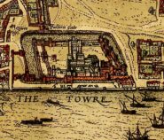
Here are several examples focused on the Tower of London. You can see two different maps. The original 1597 “Tower Liberties” map with two later copies of it. Also the 1572 Civitates Orbis Terrarum and an enlargement from that.
Maps of the Tower in the period of the Ring of Fire and surrounding areas. Read more about the history of tower hill. To view a high-resolution zoom-able version of the 1572 Braun/Hogenberg map courtesy of the British Library click here.
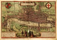
The earliest known map of London. By Braun and Hogenberg.
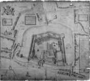
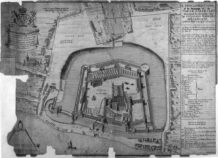
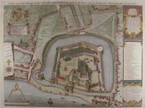
Map of the Tower Liberties surveyed by Haiward & Gascoyne in 1597.